Indian forest cover – Introduction of forest inventory in India
Forest, an area with a high density of trees is a very complex ecosystem on the earth. The FAO (Food and Agriculture Organization) has defined forest as land with tree crown cover of more than 10% and an area of more than 0.5 hectares. The Indian Government defines a forest as land having a tree crown cover value of a minimum 15%, land area value of minimum 0.05 ha, and tree height value of a minimum 2 meters. Forests are a very crucial natural resource and have always been central in human life. Forests provide renewable raw materials and energy, maintain biological diversity, mitigate climate change, protect land and water resources, provide recreation facilities, improve air quality, and help alleviate poverty.
 India’s Forest Cover accounts for 23.84% of the total geographical area of the country and tree cover (Tree Cover is defined as tree patches outside recorded forest areas exclusive of forest cover and less than the minimum mappable area of one hectare) accounts for 2.82% of India’s geographical area (State of Forest Report, 2007, Published on 2009).
Forests have a crucial role to play in a nation’s economy and hence the Government of India emphasized their importance in conservation, restoration, stability, and ecological balance in the 1988 National Forest Policy. Better forest management practices were introduced and the Indian Forest Service, one of the three All India Services, was constituted in the year 1966 under the All India Services Act, 1951 by the Government of India.
Brief Chronological View of the Management of Forest Resources in India
- 1864- Establishment of Forest Department, Appointment of Dr. Brandis as first Inspector General of Forests.
- There was a shift from the exploitative principle towards conservation and better management of forest resources.
- 1865: First Indian Forest Act enacted
- 1869: Forest Department reorganized and forest officers classified into Conservators, Deputy Conservators, and Assitt. Conservators
- 1878:Revised Indian Forest Act
- 1870 to 1910: Forest Settlement and Compilation of Working Plans
- 1894: First National Forest Policy
- 1927: New Indian Forest Act enacted
- 1878: Formation of Forest School
- 1906: Establishment of Forest Research Institute (FRI)
- 1952: National Forest Policy
- 1980: Forest Conservation Act
- 1981: Establishment of Forest Survey of India
- 1982: Establishment of Wildlife Institute of India
- 1985: Creation of MoEF (Ministry of Environment and Forests) as a separate ministry
- 1990: Launch of Joint Forest Management program
An accurate assessment of forest and tree resources in the country is essential for formulating a sound strategy for the forestry sector. It resulted in the “Pre-investment Survey of Forest Resources” (PISFR), a project initiated in 1965 by the Government of India with the sponsorship of FAO and UNDP to assess Indian forest cover. Further this project is succeeded by the Forest Survey of India (FSI), a premier institution established on 1st June 1981. FSI is involved in the assessment and monitoring of the forest resources of the country regularly.
Forest Survey of India (FSI) assesses the forest cover of the country by interpretation of remote sensing satellite data. The major activities of FSI include – Forest Cover Assessment, Inventory of Forest areas, Thematic Maps, Inventory of Trees outside Forests (Rural & Urban), Inventory data processing, Methodology Design, Training and Extension, Projects and Consultancies. FSI publishes all the analyzed data and results in a biennial report called ‘State of Forest Report’ (SFR). First SFR was published in 1987 and till now nine SFRs have been published and made available to the public.
FSI uses highly sophisticated tools of remote sensing such as Geographical Information System (GIS) and GPS in its regular activities. All these modern technologies result in a positive impact on the forestry sector in India. Previously the FSI have used data of US Remote Sensing Satellite Landsat for SFR 1987 but now FSI has shifted to the indigenous satellites – Indian Remote Sensing Satellites (IRS) LISS III sensor since 1995 till 2003. After 2003, all the Remote Sensing data is being sourced from IRS P6 Resourcesat LISS III.
Click here to know more about forest cover mapping using Remote sensing and GIS techniques
Need quick information on the topic? Click on the following images –
|
|
|


Information Source: Forest Survey of India, Ministry of Environment and Forest, Forest Research Institute, Dehradun
Share this:

Related Posts
-
 Afforestation and Reforestation (A/R) CDM projects
-
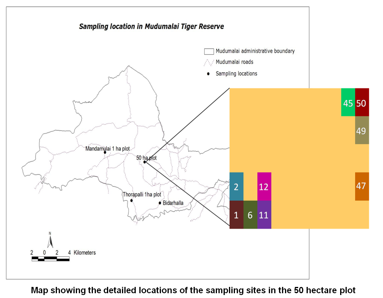 A test of the Janzen-Connell hypothesis on Syzygium cumini seedlings infected by fungal pathogens in the Dry Deciduous Forest of Mudumalai Tiger Reserve
-
 ICFRE can now validate and verify A/R CDM projects
-
 India recorded a net loss of 367 sq km of forests between 2009 and 2011
About The Author
Shailesh
Shailesh is post graduate in Environment Management from Forest Research Institute (FRI) University, Dehradun, India. Presently he is working in the areas of Environmental and Renewable Energy Advisory Services. He has started GreenCleanGuide.com during his college days.
Thanks shilesh.. for the comprehensive article..
Thanks Chaitra! Stay tuned with us for more information in the fields of environment and sustainability.
what a good article! thank you..